
We left with a Map.
Well, OK, that isn’t entirely true.
We left with a scrap of paper with the names of a couple of towns we would need to drive through written on it.
Since we were in the neighbourhood, we thought we might as well pay a visit to the famous Copper Canyon region (Barrancas Del Cobre). When we had stopped in San Felipe in Baja and spoken to Anita and Markus (bcprod.ch). Markus had very enthusiastically reminisced about their time in the Copper Canyon and I guess this had been rattling around in the back of our heads, because when we spoke to the owner of the hotel we were staying in and he asked if we planned on visiting the Copper Canyon we responded with “Yeah, sure.”
When he asked if we were planning on taking the train (El Chepe) or driving, we pondered this for a moment. The train journey is rumoured to be a pretty memorable experience. Amazing and all as the train journey sounded, we did like the convenience of the truck. He offered to give us driving directions before we left.
The day we were leaving however, he was not around, so we asked his brother, who drew us this ‘map’.
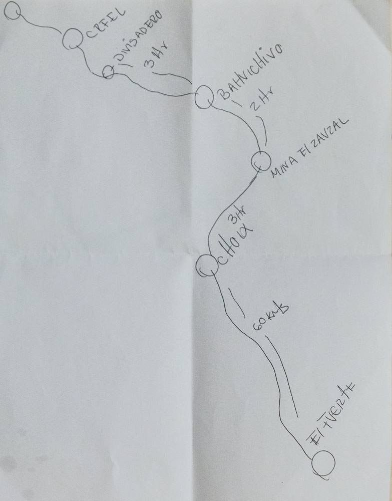
He told us the names of the towns we would need to drive through, plus the guesstimated driving times between towns. Since our Spanish wasn’t very good, we left it there, decided this was enough to go on and hit the road.
Probably a bit later in the day than we should have, given the guesstimated driving times.
After looking at the National Geographic map of Mexico that Peter and Dace had given us, we realised no roads were marked between El Fuerte and Creel on that map. (Well, not without driving the long way around.)
Probably no surprise, a simple fold out map of the country the size of Mexico does tend to only cover the main highways.
We tried google maps, but the GPS on Emma’s phone couldn’t figure out the roads we were driving on, so that proved to not be very much help beyond giving us a vague general direction.
So we asked Javier (our GPS) for a bit of help. Javier initially wanted us to go the long way around, but we followed the general direction that Google had been suggesting and tried to encourage Javier to find a more direct route (this sometimes works).
But then this happened.

Yep. That’s right. The road just ended. Just like that. 100m earlier there had been a generously wide highway, lined with the typical speed limit signs and the ones warning about fastening your seatbelt, that sort of thing. No warning that the road was just going to end around the corner. Although, had you been moving fast enough, fastening your seatbelt just before the road abruptly ended facing a cliff was probably good advice.
This looks like an important main road…until the cliff.

We had wondered why people a kilometre or so back had been giving us stranger-than usual looks.
There was nothing for it, we turned back around and looked for the sign for Mina El Sauzal. It transpired that this was a dusty turn-off marked by a very small road sign covered in trees.
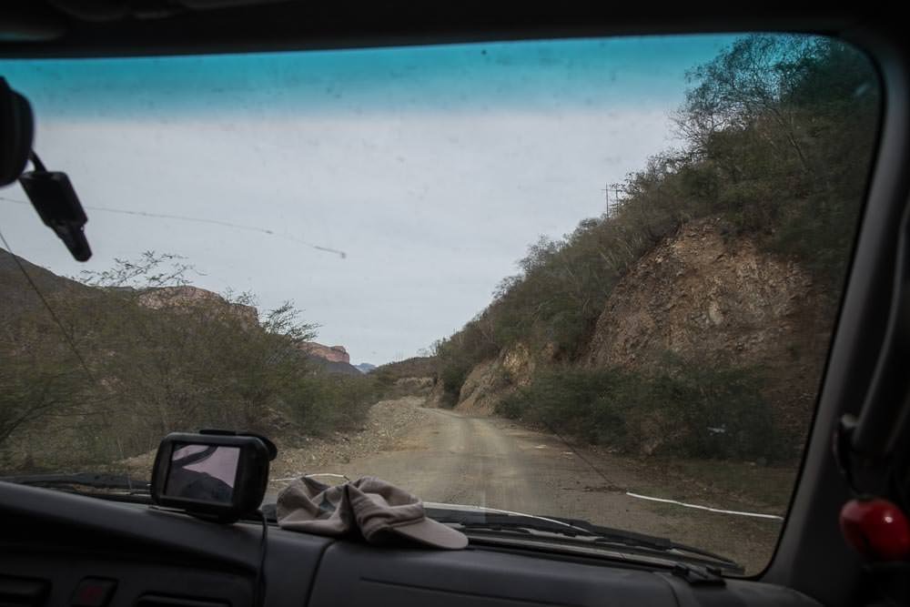
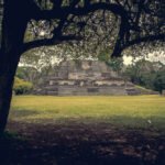
As we wound our way through the canyon the scenery became increasingly impressive. The hills became mountains, the roads more winding. We started to spot things like this ruin of a Jesuit Mission down by the edge of a river.

We saw a couple of nice places to camp, like this peaceful river bed, but it was still the middle of the afternoon at that point, so we just carried on driving.

What our paper ‘map’ hadn’t taken into account was the network of unlabelled roads we would pass as we drove.
Most times it was obvious, but as it got later in the day we arrived at a main looking unlabelled junction. It had once boasted a sign, but now the only guidance was an empty sign post. One road looked more well worn, but appeared to head in the wrong direction, the other looked rougher and pointed straight up the side of a mountain.
Of course we took the one that headed directly up the side of the mountain range.
Luckily, based on the paucity of information we had, we were heading in the right-ish direction (Javier was confident that there were no navigable roads in the area. On his screen however, we could see dots marking a couple of towns on the other side of the mountain range).
We started to pass mining vehicles and trucks full of mine workers. We were wondering if perhaps we had strayed on to private property, but we carried on regardless.
At the top of the mountain a security worker flagged us down.
We rolled down the window to speak to him.
“Buenas Tardes” He burst into a big smile “Are we gringos? Don’t worry, I speak a little English!”
…then he proceeded to speak to us entirely in Spanish.
He asked us where we were going and where we had come from, so we showed him our ‘map’. He nodded with approval. We asked if there was a road to Urique nearby as we could see the little dot labelled ‘Urique’ on Javier and thought that would be a good place to stop for the day as it was starting to get rather late.
He said (mostly in Spanish) “Yes, yes, just a bit further down this way, once you drive through Mesa de Arturo, there will be a road to the right, maybe 20 minutes or so along. You’ll love Urique, gringos love it, stay at Entre Amigos, it’s a very gringo place. An American owns it. There are cabañas and camping. Gringos love it.”
Heartened by his directions we continued the way we had been headed. There were a few more confusing points where the road seemed to split arbitrarily with no signage, but we felt like we were heading the right way. We left the mine behind us and continued heading in the direction of (hopefully) Mesa de Arturo keeping our eyes out for our turn-off.
It was getting late in the day, but we were starting to get a glimpse of the kind of spectacular views we could expect from the mountain-top roads of the Sierra Madre mountain range.

Suddenly in the road in front of us, there were three men with rather imposing looking guns.
We stopped, as you do, when instructed to do so by people bristling with assorted weaponry. As they walked up to the car, we were debating whether they were bandits or mine security.
The friendly bandits/mine security asked us where we were heading, where we had come from and who was travelling with us. We felt this line of questioning meant they were either incredibly cautious bandits, or a legitimate security crew.
The chief in charge of questioning had not only an AK47 but also a shiny chrome handgun. As he was issued with the broadest selection of offensive weapons, he was clearly the most important of the crew.
In response to the question about our travel plans, we handed him our ‘map’ he snorted derisively. When he showed it to his friends, they all had a bit of a laugh at our navigation skills. We asked if the road to Urique was still ahead, they confirmed it was and we were on our way.
By this point it was getting very late. So late that we probably should have stopped somewhere on the side of the road to camp.
However, we have already been kicked out of one camp spot by armed security once before we didn’t really want a repeat of this. Especially since our Spanish was sufficiently poor that any conversation with anyone brandishing a gun before we’d had a morning coffee was going to be problematic. So we pushed on to Urique.
One of the oft-repeated rules of overloading through Latin-American countries is: “Don’t drive after dark”. Needless to say this rule is intended to be applied even more diligently to narrow winding mountain roads with sheer drop-offs in the middle of the sparsely populated Copper-Canyon region of the Sierra Madre mountain range.
On this particular day however, we completely ignored this rule.
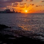
The upside of this was that we did see an impressive sunset from our perch on a ridgeline, high above the valleys below.


The downside was, that we had no way to spot a suitable campsite on the side of the road, we were committed to the finding the town of Urique. With no actual maps of the area.
Javier was still clueless.
After what was a lot longer than 20 minutes we were starting to wonder if we should give up, stop wherever, and be prepared for a potential heavily-armed wake-up call in the morning.
Then we arrived in a small seemingly un-named village.
We were just about to stop and ask a couple of locals if we could camp anywhere nearby, when we realised we were in Mesa de Arturo. A short distance out of town was a road sign, and actual road sign. Even better it was pointing to Urique—and it wasn’t very far at all.
This was enough to boost our confidence in ‘Plan A’ so we followed the road.
We didn’t know much about the Copper Canyon, but we knew the road into Urique was going to be steep and winding. As a result the short distance of 20km still took a lot of time to drive. By this point it was completely dark. The only clues to the sheer drop-offs that lurked menacingly to one side of the road were the incredibly small street lights of Urique we could see almost directly below us as we drove the sinuous road. Well, that and the rows of eerie white crosses that stood testament to those whose lives had been claimed by this narrow, winding stretch of road.
We took the corners slowly, any thoughts of speeding up were discouraged by the appearance of yet another grim white cross from the darkness, or another dizzying glimpse of the lights of the town below. As the evening wore on, the air became warmer and lights of the town grew larger and larger and we knew we would soon be arriving in Urique soon. We imagined rolling up to a campground, brewing a well-deserved cup of tea, maybe having a shower and tucking in for a restful night’s sleep.
However, it was never going to be that easy. By the time we arrived in town it was late. The last few businesses were closing up for the day and people were heading home. The location information we had managed to get for the campground proved to be erroneous, so we asked around town. All the directions we were given appeared to lead to the same general area, just through the other side of town, on the left. We were given varying descriptions of how far down this road it would be. Try as we might, we couldn’t see it.
We managed to find another campground in town, that appeared to be securely locked up with the lights off and no way in. In fact the whole town seemed to have the lights off and the gates locked. We found a hotel with an unlocked side gate, but nobody around. At this point we gave up, drove just out of town and found a quiet spot on a river bed to set up camp.
Although the scenery we awoke to was impressive enough:

We didn’t feel that there was much in the town of Urique to require us to hang around. We’d managed to get online, the 2G was slow, but we had read that campground we’d been looking for was some sort of retreat for folk that wanted to get ‘away from it all’. We felt we’d already been ‘away from it all’ so weren’t too fussed. (How far ‘away from it all’ are you, on the edge of a town with cellphone data, really?) Besides, we were intrigued as to what the views were like from the road we had wound our way down the night before.
As we drove into town from our river-side camp spot we spotted the sign for the place we had been looking for. A small white piece of wood with a hand painted name nestled into the some rocks just off the side of the road. Easy to spot by day, but no wonder we couldn’t see it after dark.


8 Comments
I just love the photo of the sunset through treelike.
Buy a Guia Roji,a map book of Mexico the size of a sheet of paper. A large Pemex may have one.
We did end up buying one of those-a good map! We still didn’t end up using it nearly enough, guess we got used to not knowing where we’re going 🙂
[…] We navigated the same winding narrow road as we had the night before. In the early morning light, the views were more spectacular and the drive was far less daunting. Although the daylight did serve to highlight the peril we had been in as we cautiously made our way down the hill in the dark the night before. […]
[…] Due to the complete lack of rain in the area we had no trouble navigating the rest of the way to Álamos. Looks like we’d vastly improved our navigation skills after the Copper Canyon debacle. […]
[…] from driving the higher, more winding, more dramatic, much narrower gravelly death-roads of the Copper Canyon, but we found the drive pretty tame and not as death-defying as it had been sold to us […]
[…] we find ourselves navigating winding and dusty back roads, such as those in the Copper Canyon or the Baja Peninsula. But what is even more of a challenge is winding our way through the narrow […]
[…] Unsurprisingly, it was after dark when we found ourselves still winding through the valleys leading to Xilitla. The first rule of overland travel is “Don’t drive at night.” We never seem to break this rule somewhere sensible. It is always on a winding, precarious mountain road with blind corners and sheer drop-offs. […]